Ep 138: Train on Your Locations - Counterstrike Terrain
Episode 138
Published Oct 6, 2026
Duration: 15:07
Episode Summary
The trauma center is ten miles out, not one. The road you blocked is the road you need. Those problems only show up when you train on your own locations — which is exactly what Counterstrike Terrain puts on the table.
Episode Notes
Most tabletop training runs on the same handful of preset locations. A school. A shopping mall. Useful for teaching principles, but never quite your problem.
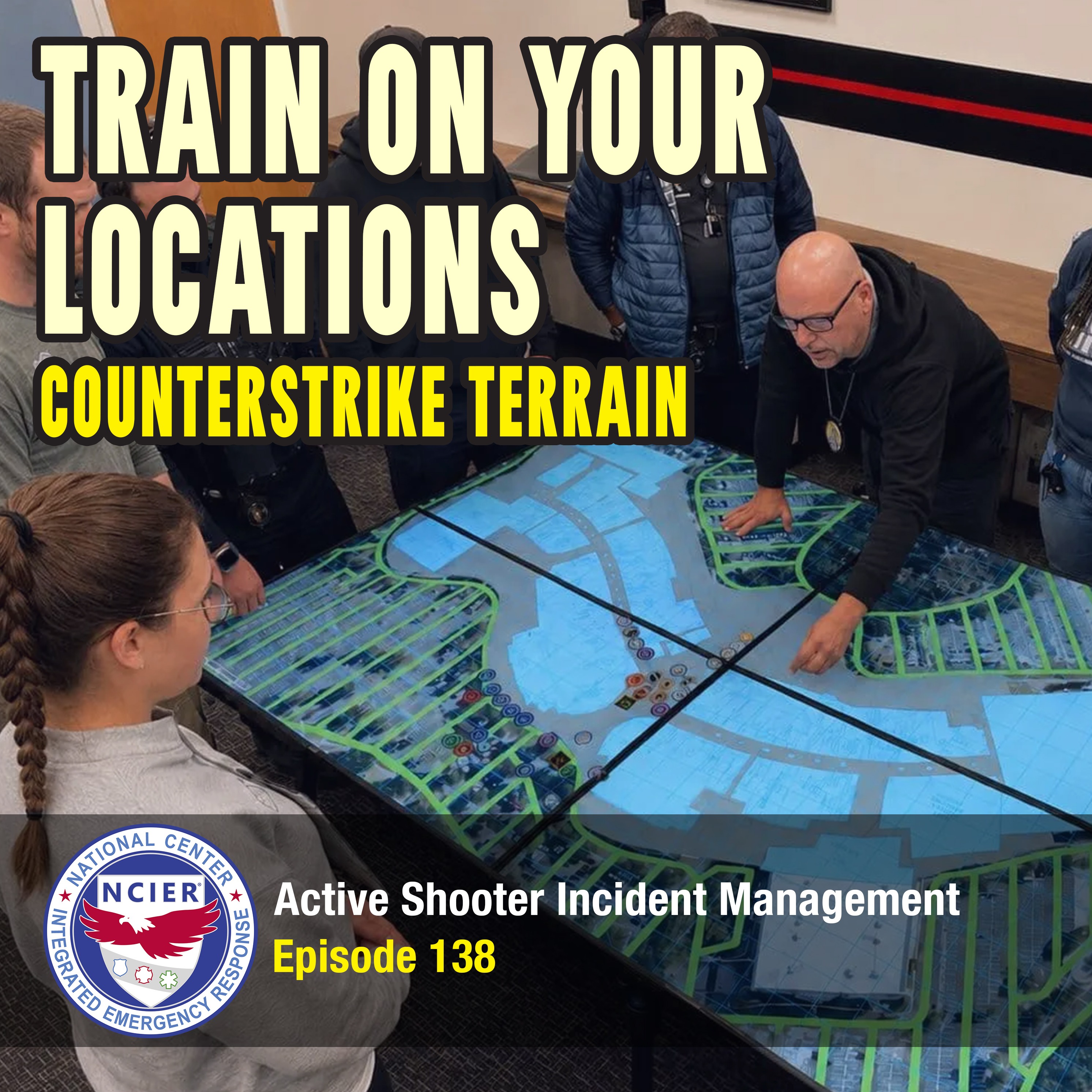
In this episode, Bill Godfrey is joined by Kami Maertz and Brian Beechner to introduce Counterstrike Terrain, the newest addition to the Counterstrike family of training products. It's a digital map table for functional exercises that pulls up any location you want — your schools, your malls, your hospitals, your target hazards — and lets a room full of people stand around it, write on it with dry erase markers, and move physical resource chips across it.
The conversation gets into what that changes in practice. Brian talks about the challenges that only surface when you train on real geography: the trauma center that's ten miles out instead of one, the roads you're very good at blocking and less good at unblocking. Kami walks through preplanning a high-risk warrant, briefing a search team on exactly where the turnaround zones aren't, and running a missing person search that scales outward as the search area grows.
They also cover splitting the display for a complex coordinated attack, so the incident and the reunification center operate as two genuinely separate problems with a real communication piece between them — no notionalizing. Plus floor plan overlays, adjustable grids, the 4' x 4' Standard and 4' x 8' Large panels, public order applications, and setting one up outside a command bus when you can't fit every incident commander onto it.
WHAT'S COVERED
- How Counterstrike Terrain differs from the preset Counterstrike printed boards
- Preplanning SWAT warrants, special events, and target hazards
- Transport routes, traffic, and perimeter decisions on real maps
- Overlaying floor plans and adjusting grid size
- Splitting the display for complex coordinated attacks and reunification
- Missing person searches and scaling the map outward
- Portability, setup, and command post use
RESOURCES
Counterstrike Terrain: https://www.c3pathways.com/counterstrike/terrain?utm_source=simplecast&utm_medium=audio&utm_campaign=podcast_ep138&utm_content=terrain
Training courses: https://ncier.org/course/catalog?utm_source=simplecast&utm_medium=audio&utm_campaign=podcast_ep138&utm_content=catalog
The National Center for Integrated Emergency Response (NCIER) uses Counterstrike Terrain in its School Safety and Violent Event Incident Management (SSAVEIM) Train-the-Trainer and Active Shooter Incident Management (ASIM) Advanced courses.
View this episode on YouTube at: https://youtu.be/7LojszP8EoU
Transcript
Bill Godfrey:How many target hazards do you have in your jurisdiction? How many times do you stand up for special events? How often does your SWAT team need to serve high risk warrants? We've got a new tool we just released that can help you do all of those things. Counterstrike Terrain.
Kami, why don't you talk a little bit about what it is and what it can do for you overall?
Kami Maertz:
So most of us know about counterstrike boards. If not, then they're pre-planned boards with preset locations really to teach the basics, teach the principles of the Active Shooter Incident Response. And they're great for that. Counterstrike Terrain takes us a step above that. So you actually can interactively build into the maps whatever location you want, personalize it to your community and utilize it, like you said, to preplan events, right? So if you have a location and you want to kind of get an overview, have all the commands stand around and really get a good overview of the incident location, be able to zoom in, zoom out, look directly at the location and what's outside of that target area.
I look at it also though for, like you talked about, SWAT operations. So we're talking about a pre-plan for a search warrant or maybe a functional active incident that's going on and we can get a good overview of that actual incident location in my community and see what we have planned or what we have out already, what containment elements do we have set? What areas have we evacuated? What areas do I need to look at next for evacuations or other safe zones? Where are my people positioned at? What additional things do I need to consider? And I can get an overview of that board with other Incident Command, Fire or Rescue Personnel, so I know where they're going to be staged at, where are they located at, what are their needs? All of that overview while the scene is actively going on.
Bill Godfrey:
Brian, for you on this digital map table, really anything you can pull up on a computer, you can project on this thing, but there's some other values with it. How do you see it being used in training? How do you see it as a game changer for training and preparedness?
Brian Beechner:
It's a game changer for training because it is my jurisdiction. So often do we train the counterstrike boards, yes, we give you, there's a school, and there's the shopping mall, but we're going to continuously train on the same locations. With the Counterstrike and now this digital map, I can bring in my target hazard. I can bring in my school. I can bring in my shopping mall. Any other target hazard I have in my jurisdiction, I can pull that up and put the streets in there, I can put business names in there, and now I'm training on that particular location. And it can change. Every single time you do a different scenario, you can change with that.
Kami Maertz:
It really personalizes it for you. Even in training, when you're talking about like actual target locations, potential target locations for us, to be able to overview it with young deputies, and for them to kind of set even basic things of where they would enter at, if the hot zone was here, if you entered from here, what area would you call that, right? So when we're teaching basic deputies about even what we call Alpha, Bravo, Charlie, Delta, or one, two, three, however you teach it, right? You can actually have the board out and these you can write on. Okay, so you can actually, with your erasable markers, go ahead and document directly on that map the locations that you're talking about. So when they're looking at it, they're actually getting that feel and being able to visualize and see what you're discussing in real time on the board so that you can change it, fix it, like you said, pick another location. If it's your mall, then you pick a school. All on the same training within a short time to be able to really document and kind of get that feel and overview of everything.
Brian Beechner:
And I think by allowing you to train on locations that are in your jurisdiction, you can come up with, there may be some other challenges that come up with that.
Kami Maertz:
Yes.
Brian Beechner:
Because if I'm training at this location, how far is it to my level one trauma center when I'm sending my ambulances out of my AEP? And we may be a mile away, but this location's four miles away or 10 miles away. Now that brings additional challenges to managing that incident.
Kami Maertz:
Yep, and traffic, right?
Brian Beechner:
Traffic.
Kami Maertz:
So our perimeter locations and what road do we need to shut down? What roads are we looking at that we need to unblock to get us to the hospitals? We talk about that a lot, right? We're really good at blocking roads. How do we unblock them? What other directions can we go to get everybody out and off the scene, get those ambulances flowing? All of those things, and we can do that in a pre-planning method so we can actually have this and look at it.
Brian Beechner:
It brings a little bit more realism to the training as this is my area. This is not a made up location. Even though the Counterstrike boards are fantastic in what they do, this is now my area, and I have a little more ownership and a little personability to that.
Kami Maertz:
Yeah.
Bill Godfrey:
I think the other piece, in addition to being able to write right on it, is with the resource chips that we have, and the markers that we have, and everything else, you can actually game this out.
Kami Maertz:
Yes.
Bill Godfrey:
Like, your situational awareness of what's going on. Now with Counterstrike and with the training, we're using it as a replica of a full scale in being able to, this is where the resources are, and this is the battle map of how things are going.
Kami Maertz:
Yes.
Bill Godfrey:
But in the reverse of that, at the command post, or in a briefing for a warrant, or preparedness for a special event, it's a chance to kind of move things around and do the what if, and then make our, this is our best case scenario, here's our fallback plan. I think it gives you all of that without getting hung up on everything being digital or a computer.
Kami Maertz:
Yes.
Bill Godfrey:
It lets you bring up that map location, whatever that location is. And if it's a large area, like you talked about a mall, a shopping center, a hospital, a school, you can also overlay the floor plan of that.
Kami Maertz:
Yes.
Bill Godfrey:
On the top of it. So you get not only the exterior, you get not only the aerial imagery, and the roads, and the buildings, but now you can insert the floor plans and that grid that it projects over the top of it, you can adjust your zoom level, you can adjust the size of the grid. It gives you all of that functionality in one shot.
Kami Maertz:
Yeah, I really also like the fact that you can split it. So you can actually make a Complex Coordinated Attack, right? So you can have two locations in your same area, or if you're using it for a school and a reunification, you can actually split those exercises on two different Counterstrike Boards or Counterstrike Terrain Boards and be able to operationally see how that is going to look, how that's going to function. You can have your reunification center up, have your operation going on at the reunification center, and still be handling your main incident. And that really puts in perspective of how that's actually going to operate, right? That you can't take people from this to be over here. It's two separate things going on at the same time. But I think that kind of, and the communication piece between both of them, right? If you have something on your operations board, you can't, you're going to have the pieces there, and you're moving them actively to the reunification. So it's that physical process of showing what you're doing and kind of acting it out. I really like that.
Brian Beechner:
It takes away a little bit of that, we're going to notionalize this or we're going to notionalize this.
Kami Maertz:
Yes.
Brian Beechner:
Now if I have those, if I have the reunification on one board and my incident on another board, now that's really happening. And I don't need to notionalize that anymore. It just, again, brings a little more realism into that training atmosphere.
Kami Maertz:
And working on the communication piece.
Bill Godfrey:
Yeah, and there's no real limit to the number of sites that you can support, just how much of the equipment do you want? And we've got the two different versions of it. We've got the standard size, which is four foot by four foot display, and then we've got the large size, which is four foot by eight foot. What I like about it, going to your point is, you get the four foot by eight foot large one, you can use it as a large panel.
Kami Maertz:
Yes.
Bill Godfrey:
You can split it and use it as two four foot by four foot panels. You can even take the four foot panels and split them in half as well. Like I know with the NTOA, who has a public order class, they're very, very excited about the ability to have the one four foot by four foot display for kind of the command post and then using the smaller displays to be these highlighted areas where there's public order issues, that there's a protest here, they're marching over here. These groups are in separate places here, but now they're moving towards each other. And it allows you to just dynamically do that, and of course do it not in a default location, but to do it in your own jurisdiction.
Kami Maertz:
Your own backyard, right? And so I think that's the biggest thing is I think it really allows you to take training to that next level to really personalize it for everyone on scene, for them really to kind of look at it and realize this could happen here. This could happen in my community. We're acting this out right here, but this is a reality. And these are what are going to be our limitations. And these are going to be what our surprises are going to be and be able to work through those issues. How are we going to fail up at this? What are we going to do? What have we implemented?
Brian Beechner:
And to the point of that, I like it for special events. If I know I have a special event coming in my area, first I'm using it for training. Hey, we're going to bring everybody that's going to be involved in this special event here. Here's our location, here's where our command post is going to be, and we're marking all those things. And then I bring that Counterstrike Terrain Board to the actual special event and I set it up that exactly like that in the command post so everybody's on the same page. We've already trained on this, here it is.
Kami Maertz:
Well, I even like it, we had, what I was looking at originally is even like missing children, missing people, is that, as we're talking about scalability, right? Is that we have it right here, and here's our zoomed in location that we're looking at. These are the areas we searched. As that search location goes bigger, we can just expand that map out. We can reduce the size, right, and go bigger and bigger, and start looking at hazards around there. Where else has this child gone or this person gone? What other areas do we need to search? And really visually be able to stand over it, have the poker pieces, right, and move them around to where you're actually putting people in those locations and you're visualizing it, but you're doing it in real time.
Brian Beechner:
I think about areas like, okay, let's just utilize it. Every state has a state fair. We're utilizing it at the state fair. There's missing kids every single day.
Kami Maertz:
Yes.
Brian Beechner:
And now I'm using my Counterstrike Terrain Board.
Kami Maertz:
You're looking at it.
Brian Beechner:
I'm looking at the board. This is where we've already searched. This is where we think the child may be, and we're just using that to just.
Bill Godfrey:
Yeah, I think it's a real game changer for training and operational components both. And I like the portability aspect. And of course now it's like you got to put an asterisk by the portability thing, right? So it does fold down. It's about a single panel is four foot by two foot, and then it's about six inches of depth. That's without the casing on it. If you're going to move it in the back of an SUV, no problem. You slide a couple of these things in easy enough. But you're not going to hand these things off to UPS or FedEx to move around that way. And so if you're, like in our business, we're operating and training all across the country. That's a different level of casing that's needed than, "Hey, can I borrow it to go do some training at so-and-so school? And I'm going to put it in the back seat of my car or I'm going to put it in the back of the SUV." And so when you do have to ship it, there are some additional concerns and issues. But if you're really just getting it for your local jurisdiction, it's pretty easy to move around, fold up, and deploy.
Brian Beechner:
You know, many agencies or jurisdictions have those large command buses. And this is a great supplement, because when I'm trying to dish out responsibilities, and I'm bringing Incident Commanders or I'm bringing all my fire engines in, I can't bring them all into my bus to show them the TV on my bus. Now I can bring this and set it up outside, and now that's just a supplement. Hey, everyone gather around here. Here's our operational plan. Here's the command, this is where we're going to go.
Kami Maertz:
And for your remote ones, your Remote Incident Command, when you're setting those locations up, your command posts, we recently had a missing person where we set up in a church. We didn't have all our beautiful boards and all of the beautiful things, right? It's that we were working operationally within this small facility. But it definitely would've had enough space for us to put the map out, have everyone stand around and say, "This is what our goal is, this is what we're looking at." And we're not working with paper maps, right? We're hanging on the wall and you're not really getting good visualization. When I have a search team that's going out to a direct area, I can actually zoom in and say, "This is your area." Whatever it is, whatever operationally it is. If it's a search warrant, we can actually pull it up and actually look and say, "Hey, this is where you're going in. If you drive down this road, this is where your limitations are going to be. There's not going to be a turnaround zone." Whatever it is, and so that they can actually visually, but you can zoom in and say, this is what your concerns are here.
Bill Godfrey:
I think it's not terribly intuitive that, well, wait a minute, what's the difference between that and being a projector on the wall or being on a display or a mount? Why is making it a table making a difference? I don't know, but it does.
Kami Maertz:
It does.
Bill Godfrey:
It just does.
Brian Beechner:
It really does.
Bill Godfrey:
And when you can get everybody around it, they can all have a perspective looking at it. You can use the dry erase markers to mark up and illustrate things, to circle things for your briefing that could be temporary markings or permanent markings to be able to put your resource chips in. This is where staging's going to be. Here's where our perimeter's going to be. If this goes badly, this is the plan of how we're going to deploy these resources here. It lets everybody be around it at the same time with their hands on it, moving it.
Kami Maertz:
Yes.
Bill Godfrey:
And in the course, in the command post, and in training, it's the same kind of thing. It's not one person reaching in to move chips.
Brian Beechner:
Right.
Bill Godfrey:
Or move resources. It's a whole bunch of hands.
Kami Maertz:
Yes.
Bill Godfrey:
And so when you mix this digital map display with the physical tokens and the ability to stack this stuff. Game changer.
Kami Maertz:
It really does, it goes to the next level. When you're looking at it, it's really impressive just to look at. But the ease of use of it and just the functionality in so many different aspects for your agency is really remarkable.
Brian Beechner:
Yeah, it's a quick setup, and it takes no time at all and you can have it operational. And again, using it as training, and then pushing it out into your incidents.
Kami Maertz:
Yeah.
Brian Beechner:
When you have a piece of equipment that is multi-versed, where you can use it for multiple different things, that's what a lot of people are looking for.
Kami Maertz:
Absolutely.
Bill Godfrey:
Yeah, so Counterstrike Terrain, brand new addition to the Counterstrike family of training products.
Kami Maertz:
Yes.
Bill Godfrey:
Available on the website, on the c3pathways.com website. In fact, Karla, would you make sure that you kind of put that up for everybody on the link? Any last thoughts on that?
Kami Maertz:
No, I'm just super excited about getting it and getting it implemented.
Brian Beechner:
Super excited, it's a great product.
Bill Godfrey:
Yeah, we're going to add it both to the advanced class and also to the SSAVEIM class, the School Safety and Violent Event Incident Management class, even though that creates some logistics for us. I may be sorry about that, but.
Brian Beechner:
It's going to be a game changer.
Bill Godfrey:
Yeah, it's going to be a game changer, good stuff. All right, well, Brian, Kami, thank you very much.
Kami Maertz:
Thank you.
Bill Godfrey:
For coming in to talk about this. If you have any questions or you need anything, give us a call, shoot us an email. Always happy to help. And thank you to our producer, Karla Torres, and until next time, stay safe.